
There is a lot of ignorance in this thread. People should learn about who lives where and the lineage of the clans they are talking about.
Firstly, none of the maps and figures being used here are in any way accurate or reflect the clan make up of Greater Somalia.
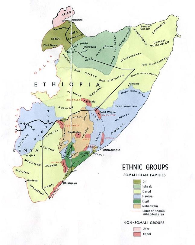
For example, in the above map, the Marehan and the Degodi do not share a border at Beled Xawo. It is the Garre that mainly inhabit Mandhera County. The Murulle are also excluded from the above map. Furthermore, the Degodi; Garre; Xawaadle and Galjeecel are not Hawiye but stand alone Samaale subclans. Western scholars bought into the biased narrative that Somalis are composed of 4 or so clans.
The way K5 is settled is also incorrect. Before the removal of the three Gurre Woredas, Southern Afdheer was settled by the Gurre; Gaadsan; Surre and Garire. The Ogaden and Degoodi did not really border each other. The Gurre had three woredas, Gariire in Ceelkari woreda, Gaadsan live on the West Bank of Jarrati Woreda, the Surre in Dolobay Woreda. Even the Northern K5 map is inaccurate, the Isaaq no longer live on the outskirts of Jijiga; the Yabarre are in between them and Jijiga. The Bajuni do not also predominately inhabit Kismayo as stated in the map. Even the CIA map which is based on second hand information and not field research, does not do Somalis justice.
Secondly, no clan census has ever been conducted. Even the first attempt at conducting a clan census ( Report on general survey of British Somaliland 1944 ) acknowledged the difficulty in estimating the population of Somali clans and argued that it was a sensitive subject among Somalis who were not willing to share the population figures for their clan. Furthermore, clans such as the Gadabursi and Ciise were found to inhabit Ethiopia more than Somalia. Most of the clan stats that people are throwing around here are based on that flawed paper.
If one was to make a comparison of Somali clans, the best way to go about is to look at the Deegans of the clans in question and their estimated population by a government census (Ethiopian CSA 2007) or the UN 2014 population estimate. The second one ain't perfect but it is the closest thing we have to a population cesnsus in the Somali Republic. In such a scenario, I would argue that within the borders of the Somali Republic, the largest clan is the Digil iyo Mirifle. Apart from the fact that they inhabit Bay iyo Bakool, they form the majority of Lower Shabelle and the bulk of IDP's throughout Somalia. Even in Banadir, they constitute a considerable percentage of the settled population in districts such as Madina. One cannot also forget that they also live on the Eastern Bank of Jubbaland. Darood would come second, Isaaq third, Proper Hawiye fourth.
It is a completely different picture when one looks at Greater Somalia; Darood is first by a mile then Dir comes second because a lot of people forget that there are around 2 millions Dirs when all their Woredas in K5 and the Dire Dawa Federal Region are added together. When the Dirs in Djibouti, the Quranyow Garre in Mandhera District and the Dirs (Awdal and Italian Somaliland) in Somalia proper are also included, they easily exceed three million. Nonetheless, if Isaaq is added as a Dir subclan, then it gets close between Dir iyo Darood. If shit becomes Irir and Darood, no contest!
What is your estimation of the demographics in DDSI?