Azania

Status
Not open for further replies.

Factz

Factzopedia
VIP
https://www.google.com/search?q=clan+mapof+Somalia+1977&client=firefox-b-1-ab&tbm=isch&source=iu&ictx=1&fir=AqbqLOoHRHxH8M%3A%2C56P1qJdFswY3SM%2C_&usg=__P3hEP1W-UpvFlTgNMipcRoJLqTA=&sa=X&ved=0ahUKEwjRpr-rwoPbAhVBi1QKHaS9ANkQ9QEIKzAA#imgrc=AqbqLOoHRHxH8M:

map-somalia-clans-1977.jpg

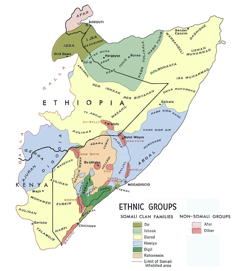
Your map is not linked and is certainly not accurate. This map, although circa 1977, shows the Gosha Sultanate as the pink area in the Lower Jubba. The Geledi Sultanate was incorporated into Italian Somaliland in 1908, and at the time of your map all the blue and gray areas were under Italian administration.

I'm sorry you're making things worse for yourself. The clan map you have shown is extremely inaccurate. Bantus do not surround Beledweyne or any Shebelle river and Jubba river areas. Bantus do not surround Baidoa or Afgooye. Hawiye borders Galkayo and lives in northern galgaduud and southwest of Mudug. Darood (Marehan) only live on the border of Ethiopia and Somalia. Isaaq territory in Hawd goes far deeper and also in eastern Somaliland they go deeper. I can mention many more errors in that map alone. You really don't know anything about Somalis do you?

The map you even shown even shows Rahanweyn living on the eastern side of Jubba river but anyways, the map I have shown you is an accurate map and was made during the protectorate era of Somalia.

Again, Gosha were Bantu slaves for Geledi Sultanate to work on the Jubba plantation so stop your fabrication please.
 
protectorate era of Somalia.

:siilaanyosmile:1915 was even before the Fascist period. The protectorate period you are thinking of comes after the Italians lose WWII, when the UN gave Italy 15 years to prepare Somalia for independence. 1945-1960.

You are partly right. The Makanne, Shidley, Shabelli, Gabaweyn, etc. are not Bantu. Geledi plantations on the Jubba? Only in Gedo.
Whitey from UK struggled to control JL because of the southern Darod brudda why do you like talking out of your ass so much
 

Factz

Factzopedia
VIP
:siilaanyosmile:1915 was even before the Fascist period. The protectorate period you are thinking of comes after the Italians lose WWII, when the UN gave Italy 15 years to prepare Somalia for independence. 1945-1960.

You are partly right. The Makanne, Shidley, Shabelli, Gabaweyn, etc. are not Bantu. Geledi plantations on the Jubba? Only in Gedo.

Somalia as a whole was never really colonized. Just local Somali Sultanates signing treaties with the Italians and British for the protectorate. Somalis were never really a colony but more like a client state that had their own governance and rights while pledging loyalty to the Europeans.

The Bantu tribes you keep mentioning were Bantus who adopted the Somali tribal system from their slave masters during the early modern period.

I'm sorry but the entire Jubbaland had Rahanweyn settlements and was governed by the Gobroon dynasty of Geledi Sultanate. The Gosha were simply slaves working on the Jubba plantation to keep the Geledi Sultanate economy running. Tell me why was Kismayo considered a port for Geledi Sultanate? Why is there Geledi ruins in Jilib and Bu'aale? You're clearly playing yourself. The Italians even said Geledi Sultanate controlled eastern side of Jubba river and mention nothing of Gedo so as @nine said stop speaking out of your ass, please.

:comeon:NO.

Kismayu was a Bajunni Degaan. The Geledi didn't use that port, never had a port. Yusuf of the Geledi was killed at Golwayn, trying to get a port, remember.?

Having lived in Jilib I can tell you with certainty that there are no Geledi ruins there.

The Geledi ruled northeast of Afgoye, Bay, Bakool and Gedo. They did not rule or have plantations in the Middle or Lower Jubba. The slaves escaped from the Middle Shabelli after about 1840 and were strong enough to beat the combined Ogaden by 1890. The British managed to control the Darood and kept the NFD. They gave Jubaland to the Italians as payment for support in WWI. The British were not ashamed of their treaty with Nassib Bundo and I doubt the Darawish woujld have refused Goshan assistance. They may have been ex-slaves, but they had guns and they were organized and knew how to fight.

You should be named "Doesn't Like Inconvenient Factz", or Factsdiid.
 

Factz

Factzopedia
VIP
Opone = modern Garacad

Mosylon = modern Qandala or Bosaso

@Yonis Modern day Opone was Hafun while modern day Mosylon was Bosaso.

You had other ancient cities in Puntland called Botiala, Cape Guardafui and Damo. I can mention more about Somaliland and Konfuur too and their successors.

Also, do you think Majerteen living in PL today are the ancestors of these people who had city-states or do you straight away believe in the Banu Hashim banging Dir women produced your clan?
 

Yonis

Puntland Youth Organiser
FKD Visionary
VIP
@Yonis Modern day Opone was Hafun while modern day Mosylon was Bosaso.

You had other ancient cities in Puntland called Botiala, Cape Guardafui and Damo. I can mention more about Somaliland and Konfuur too and their successors.

Also, do you think Majerteen living in PL today are the ancestors of these people who had city-states or do you believe the Banu Hashim banging Dir women produced your clan?
I have no idea. Theres hardly any information on those city states
 

Factz

Factzopedia
VIP
:comeon:NO.

Kismayu was a Bajunni Degaan. The Geledi didn't use that port, never had a port. Yusuf of the Geledi was killed at Golwayn, trying to get a port, remember.?

Having lived in Jilib I can tell you with certainty that there are no Geledi ruins there.

The Geledi ruled northeast of Afgoye, Bay, Bakool and Gedo. They did not rule or have plantations in the Middle or Lower Jubba. The slaves escaped from the Middle Shabelli after about 1840 and were strong enough to beat the combined Ogaden by 1890. The British managed to control the Darood and kept the NFD. They gave Jubaland to the Italians as payment for support in WWI. The British were not ashamed of their treaty with Nassib Bundo and I doubt the Darawish woujld have refused Goshan assistance. They may have been ex-slaves, but they had guns and they were organized and knew how to fight.

You should be named "Doesn't Like Inconvenient Factz", or Factsdiid.

I don't know how you going to keep defending your undocumented made up lies but Kismayo was a Somali settlement established by the Ajurans and was known as plantation port for the Ajuran Kingdom by Vasco da Gama so please stop lying. Kismayo was also a port for Geledi Sultanate so was Barawa. I mean they even controlled Mogadishu and Lamu at their height. Failing to colonize Merka doesn't mean they didn't have access to the coast you old fool. You keep contradicting yourselves, first, you said they were natives and now you accept they were ex-slaves after I debunked you?

You're making a fool out of yourself. Geledi Sultanate controlled Lower Shebelle except for Merka district, they also ruled Bay, Bakool, Gedo, Middle Jubba and Lower Shabelle. The Gosha were simply slaves working for the Jubba plantation to keep the Geledi Sultanate economy running and Nassib Bundo was simply an ex-slave and a tool for Sheikh Uways Al-Barawi so quit lying. Geledi Sultanate did fight and resist the Dervish State around northern Bakool area and it's been documented.

I've shown you the source how Geledi Sultanate even dominated the East African trade so stop making your own lies up and I've shown you the map too. So accept the facts and get lost.
 

Von

With blood and Iron will we reach the fatherland
Why does Grant even care about Somali history ? i have always wondered that :ayaanswag:
 
Why does Grant even care about Somali history ? i have always wondered that :ayaanswag:


I was a victim of the Somali history told in the 1960s. You remember, Somalis had Arab daddies and just one ethnicity; they had only one religion and spoke only one language. Then I was sent to Jilib, which spoke Boon and Maay, little to no "Somali" and which was largely Gosha. It came as a true shock to me that these people were not welcome in Kismayu.

I had no resources in Jilib to increase my ability to communicate or to understand the situation I had been immersed in. I had very limited means of travel, and was isolated for one period of 10 months due to heavy rains and mud. I became depressed and was evacuated when I was finally able to get back to Mog. After that, it became imperative I figure out what had happened.

In 2005 I got a computer and joined Somnet, beginning my education. I use the topics here for research and report back on my findings as a means of organizing what I find. It's part of my personal educational process.

I had a history major and a course specifically in historiography, so the boastful, linkless misinterpretations that are often found here are offensive. Reading comprehension counts. The only Somalis who get discredited are those who refuse, or are unable to read. Folks that also claim to have linked material elsewhere but have not are some of the worst. I sometimes do enjoy playing Beendiid, but for the most part, I am just continuing my education.
 

Factz

Factzopedia
VIP
I was a victim of the Somali history told in the 1960s. You remember, Somalis had Arab daddies and just one ethnicity; they had only one religion and spoke only one language. Then I was sent to Jilib, which spoke Boon and Maay, little to no "Somali" and which was largely Gosha. It came as a true shock to me that these people were not welcome in Kismayu.

I had no resources in Jilib to increase my ability to communicate or to understand the situation I had been immersed in. I had very limited means of travel, and was isolated for one period of 10 months due to heavy rains and mud. I became depressed and was evacuated when I was finally able to get back to Mog. After that, it became imperative I figure out what had happened.

In 2005 I got a computer and joined Somnet, beginning my education. I use the topics here for research and report back on my findings as a means of organizing what I find. It's part of my personal educational process.

I had a history major and a course specifically in historiography, so the boastful, linkless misinterpretations that are often found here are offensive. Reading comprehension counts. The only Somalis who get discredited are those who refuse, or are unable to read. Folks that also claim to have linked material elsewhere but have not are some of the worst. I sometimes do enjoy playing Beendiid, but for the most part, I am just continuing my education.

Thanks for contradicting yourself again. Maay is a Somali dialect and reer Jilib spoke maay? The Bantus that also speak Maay used to be enslaved by Rahanweyn during the Geledi Sultanate period.

I rest my case. :drakekidding:
 
I was a victim of the Somali history told in the 1960s. You remember, Somalis had Arab daddies and just one ethnicity; they had only one religion and spoke only one language. Then I was sent to Jilib, which spoke Boon and Maay, little to no "Somali" and which was largely Gosha. It came as a true shock to me that these people were not welcome in Kismayu.

I had no resources in Jilib to increase my ability to communicate or to understand the situation I had been immersed in. I had very limited means of travel, and was isolated for one period of 10 months due to heavy rains and mud. I became depressed and was evacuated when I was finally able to get back to Mog. After that, it became imperative I figure out what had happened.

In 2005 I got a computer and joined Somnet, beginning my education. I use the topics here for research and report back on my findings as a means of organizing what I find. It's part of my personal educational process.

I had a history major and a course specifically in historiography, so the boastful, linkless misinterpretations that are often found here are offensive. Reading comprehension counts. The only Somalis who get discredited are those who refuse, or are unable to read. Folks that also claim to have linked material elsewhere but have not are some of the worst. I sometimes do enjoy playing Beendiid, but for the most part, I am just continuing my education.
You have PTSD due to your time in Somalia .Have you sought help ?
 
Azania is southern Somalia, particularly the Banadir.

Swahili civilization grew out of Azania as it spread south, the first great center was Mogadishu where the "seven brothers of al-Haasa" first came to before founding the Swahili cities further south.
 

Factz

Factzopedia
VIP
Azania is southern Somalia, particularly the Banadir.

Swahili civilization grew out of Azania as it spread south, the first great center was Mogadishu where the "seven brothers of al-Haasa" first came to before founding the Swahili cities further south.

Look at the ancient map of Romans and it literally shows Azanians were southern Cushitic people that ruled the Swahili coast long ago. Southern Somalia and Northern Somalia were known as the Barbara region that had city-states and the ancient people is believed to be modern day Somali ancestors.
 
Look at the ancient map of Romans and it literally shows Azanians were southern Cushitic people that ruled the Swahili coast long ago. Southern Somalia and Northern Somalia were known as the Barbara region that had city-states and the ancient people is believed to be modern day Somali ancestors.

There are no contemporary maps of Azania, modern maps are conjecture but falsely attribute Rhapta with Dar es Salaam and the Rufiji delta rather than the Jubba river delta. This is clear if you read the contemporary accounts of the Periplus of the Erythraean Sea and also Ptolemy's Geographica. Azania is actually a transliteration into Greek of the Arab word for the Banadir coast, which is the Ajam Coast.
Ajam = Azania. (-ia means land)

This is largely due to lazy academics looking for islands to correspond with the islands listed in the Periplus with Rhapta being across from those islands, and picking Zanzibar and Pemba Islands, but this cannot be Rhapta because Rhapta is just across from these islands and Zanzibar is actually quite far from the coast. The islands are clearly the Bajuni Islands and Rhapta is probably Kismayo, the port of Kismayo was originally an island.
 
Last edited:
From the Periplus of the Erythraean Sea:
"Beyond Opone, the shore trending more toward the south, first there are the small and great bluffs of Azania; this coast is destitute of harbors, but there are places where ships can lie at anchor, the shore being abrupt; and this course is of six days, the direction being south-west. Then come the small and great beach for another six days' course and after that in order, the Courses of Azania, the first being called Sarapion and the next Nicon; and after that several rivers and other anchorages, one after the other, separately a rest and a run for each day, seven in all, until the Pyralae islands and what is called the channel; beyond which, a little to the south of south-west, after two courses of a day and night along the Ausanitic coast, is the island Menuthias, about three hundred stadia from the main-land, low and wooded, in which there are rivers and many kinds of birds and the mountain-tortoise. There are no wild beasts except the crocodiles; but there they do not attack men. In this place there are sewed boats, and canoes hollowed from single logs, which they use for fishing and catching tortoise. In this island they also catch them in a peculiar way, in wicker baskets, which they fasten across the channel-opening between the breakers."

Ptolemy's Geography:
http://penelope.uchicago.edu/Thayer/E/Gazetteer/Periods/Roman/_Texts/Ptolemy/4/7*.html
 
Now the identification of the Rufiji Delta is based on Menuthias being Zanzibar or Pemba, but both of those islands are quite mountainous, not "low and flat"

Menuthias is probably Pate island, and the "Pyralae islands" are the Bajuni Islands, with the channel between the islands and the mainland.
 
Status
Not open for further replies.

Trending

Top