
You are using an out of date browser. It may not display this or other websites correctly.
You should upgrade or use an alternative browser.
You should upgrade or use an alternative browser.
ANALYSIS What's Stopping Puntland Housing Boom?
- Thread starter DR OSMAN
- Start date
Simple answer, lack of a viable population.
Puntland region was the least populated area in the former Somali Republic:

According to published figures, Puntland region had one of the lowest recorded population density figures not only in the former Somali Republic, but across the entire African continent:

To put this in perspective, population density in Puntland region was equivalent to the Sahara desert which has a density of roughly 1 person per square mile.
Puntland region was the least populated area in the former Somali Republic:
According to published figures, Puntland region had one of the lowest recorded population density figures not only in the former Somali Republic, but across the entire African continent:
To put this in perspective, population density in Puntland region was equivalent to the Sahara desert which has a density of roughly 1 person per square mile.
This thread about Housing and this guy start troll on MJ population as the only clan live in PLSimple answer, lack of a viable population.
Puntland region was the least populated area in the former Somali Republic:
View attachment 174076
According to published figures, Puntland region had one of the lowest recorded population density figures not only in the former Somali Republic, but across the entire African continent:
View attachment 174079
To put this in perspective, population density in Puntland region was equivalent to the Sahara desert which has a density of roughly 1 person per square mile.
 .
.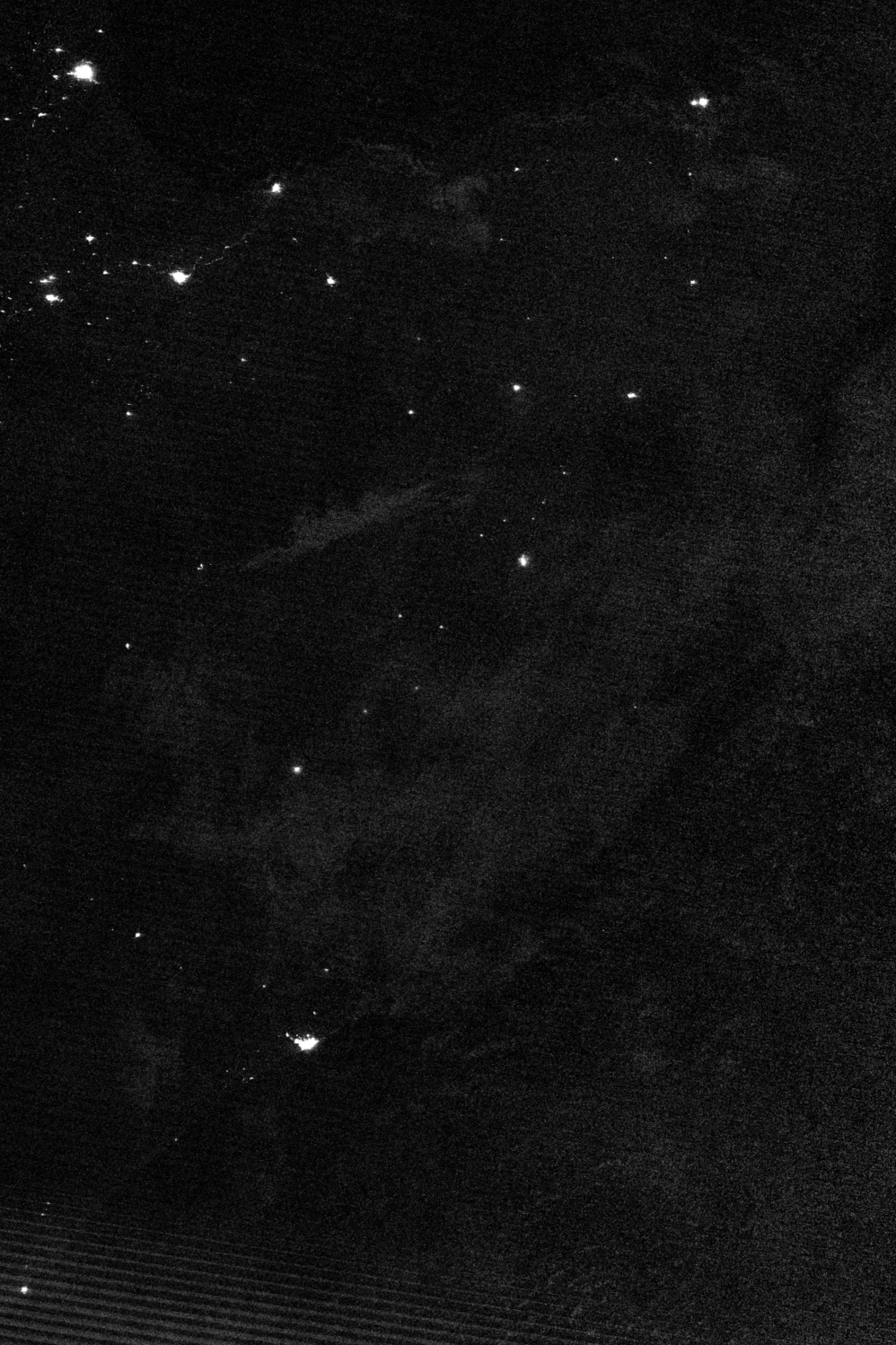

Somalia map
 .
.Somalia map
Yeah, it is Somalia at night. It shows you how large MJ is. Of Somalia's 13 most visible settlements, 4 are MJ.
Why are you using Garissa to extrapolate the population of Puntland and not historical census or voting registration carried out there
Historical census don't work cause one they're using 'estimations' and we don't know what data reference point they used, I am using Garissa model because it's semi desert like PL and extropolating their census data over to PL estimation. I am providing my model but all those historical models just give us numbers but no 'formula or model used' so it's just numbers out of their ass like UNFPA which I disproved as Hargeisa and Burco listed 90% ghost villages for their 'zone' and the south was notorious for it also.
That's why the SFG looks stupid and not credible to the world using fake estimation data in it's official govt shows an incompetent government, it doesn't impact on PL, as we have our own statistic department.
This is far more reasonable model, u can go look at Garissa population and extrapolate their land size with your own land size. The other reason older estimations don't work is PL migrated to JL/Mogadishu in large numbers after majerteniya sultanate collapsed in 1927.
That banadir estimations from historical records estimates includes Majerten being either the largest or second largest clan in Mogadishu and Kismayo at the time.
No joke Mogadishu being the largest and Kismayo being third largest cities, and ironically Majerten is second largest clan in Hamar at the time plus the largest clan in kismaayo, while still having PL population left over. Not much has changed except the fact PL is now repopulated by large exodus of southern majertens who migrated back from the south.
0117
Reborn
Historical census don't work cause one they're using 'estimations' and we don't know what data reference point they used, I am using Garissa model because it's semi desert like PL and extropolating their census data over to PL estimation. I am providing my model but all those historical models just give us numbers but no 'formula or model used' so it's just numbers out of their ass like UNFPA which I disproved as Hargeisa and Burco listed 90% ghost villages for their 'zone' and the south was notorious for it also.
That's why the SFG looks stupid and not credible to the world using fake estimation data in it's official govt shows an incompetent government, it doesn't impact on PL, as we have our own statistic department.
This is far more reasonable model, u can go look at Garissa population and extrapolate their land size with your own land size. The other reason older estimations don't work is PL migrated to JL/Mogadishu in large numbers after majerteniya sultanate collapsed in 1927.
That banadir estimations from historical records estimates includes Majerten being either the largest or second largest clan in Mogadishu and Kismayo at the time.
No joke Mogadishu being the largest and Kismayo being third largest cities, and ironically Majerten is second largest clan in Hamar at the time plus the largest clan in kismaayo, while still having PL population left over. Not much has changed except the fact PL is now repopulated by large exodus of southern majertens who migrated back from the south.
Well hopefully the PL registration for election can add more to this field soon.
Well hopefully the PL registration for election can add more to this field soon.
Check out this puntland polling stations. Qardho alone has 21 polling stations representing 'xafaado and villages'
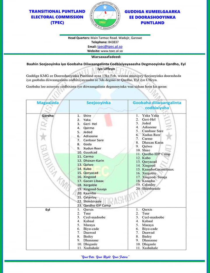
Ufayn ayaa haysto 11 xafaads or villages
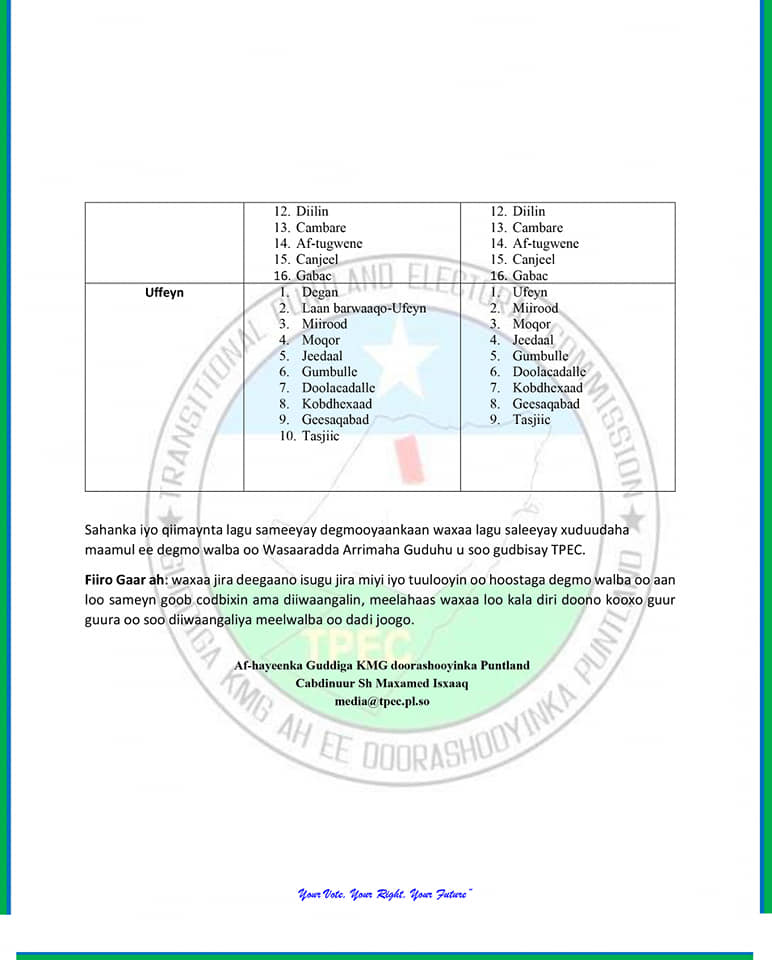
Qardho is 'average' town in PL, it's definitely only 'B grade'. So u can imagine Galkayo-Bosaso how many 'xafaads' and villages report to them as their A grade cities.
21 'xafaads' is probably '4 degmos' in my opinion. 5 villages or xafaads consist of each 'town'. So Qardho and it's surrounding area is basically 4 towns with 5 xafaads each. Wallahi Qardho is way bigger then Hargeisa
0117
Reborn
Check out this puntland polling stations. Qardho alone has 21 polling stations representing 'xafaado and villages'
Ufayn ayaa haysto 11 xafaads or villages
Qardho is 'average' town in PL, it's definitely only 'B grade'. So u can imagine Galkayo-Bosaso how many 'xafaads' and villages report to them as their A grade cities.
21 'xafaads' is probably '4 degmos' in my opinion. 5 villages or xafaads consist of each 'town'. So Qardho and it's surrounding area is basically 4 towns with 5 xafaads each. Wallahi Qardho is way bigger then Hargeisa
We shall see when the statistics come out.Will @ you when it's live.
Yeah, it is Somalia at night. It shows you how large MJ is. Of Somalia's 13 most visible settlements, 4 are MJ.
That's interesting lets collect our evidence and pile it up for a 3.5 million population for Majerteniya. I use the garissa model but i extroplated your 'lights' data, 4 out of 13, gives us 30% of Somalia electricity usage. So that's two data points saying the same thing.
Garissa model is saying 1 million for 45000 sq km land mass, majerteniya is 150,000 sq km, that means 3.3 million. Somalia over-all population is 12 million, that means 27.5% is Majerten using garissa model but if you use your light theory it's 30% for majerten. Either way majerten is 27% to 30% depending on what data point u want to use.
Add Mogadishu historical census, the town was largely majerten in 1927-1991, plus we had kismayo by ourselves as third largest an we still had puntland popultion to add. Nothing has changed, Majerten is 30% of Somalia
@TabK ask any mj or darod or even hawiye, war anagu 'intan hal ama labo meel iskuma imaano' nama deeqo labo degmo like hargeisa and burco. Bosaso jifi jifi ayaa loo dega sida ali saleban(not even all ali saleman live there)-bah gareen(not even all osman live there). Galkayo wa 'reer mahad' majority, u see 'wa jifi'. Jariban wa Jifi. Garowe waxaa dega 'wa jifi hoose issa mahmoud'.
Nigga we got Kismaayo-Bosaso-Galkacyo-Garowe-Qardho-Burtinle and waxaa dego waa 'jifoyin' can u say the same thing about hargeisa-burco where all 'isaaq' ayaa isu tagay and your still tiny as f*ck because maba haysatan 'degmoyin' ka baxsan hargeisa iyo burco. What u consider degmo like erigavo-berbera-gabiley anagaa waxan uu aragna 'tuuloyin' dhinaceena like 'carmo'
Nigga we got Kismaayo-Bosaso-Galkacyo-Garowe-Qardho-Burtinle and waxaa dego waa 'jifoyin' can u say the same thing about hargeisa-burco where all 'isaaq' ayaa isu tagay and your still tiny as f*ck because maba haysatan 'degmoyin' ka baxsan hargeisa iyo burco. What u consider degmo like erigavo-berbera-gabiley anagaa waxan uu aragna 'tuuloyin' dhinaceena like 'carmo'
codewebsduh
VIP
That's not how it works, density determines the population not the land mass. NFD is most likely more dense then Puntland due to the agricultural scene.Garissa is 45000 SQ KM and is 1 million censused by Kenya. We can extrapolate PL is 150,000 SQ KM, it is 3.3 times larger by land mass, so it's 1 million(garissa population) x 3.3 = 3.3 million for Puntland. Plus mind you this is 95% majerten population, where-as mogadishu is at best 60% hawiye with the rest of cad-cads-Madow-somalis accounting for the rest.
Mogadishu isn't 3 million either, it's 1.5 million maximum after u measure '1 km x 1 km' and assume a density rate of 5 per household and the city area sq is 90 sq km.
Look at this way if Mogadishu is 3 million, that would mean in each area sq kilometer the density rate is 33000. 3 million/90 is 33000 per area sq. How is it 1000 meter by 1000 meter inay ku nool yihin 33000, that would indicate their is 33000/5 per household, that means u will find 6600 properties in 1 area sq to have population of 3 million.
Me and @Thegoodshepherd talked about this topic and concluded hamar is 1.5 million max with 200-300k for south west IDPS. For 1.5 million population that indicates a housing rate of 1.5 million/90 area sq = 16000 people. This means 1 area sq/16000 ppl will give u housing ratio of 3200 houses in 1 area sq which is more likely then 6600 houses in 1 area sq.
Maybe me and @Thegoodshepherd can carry on this discussion, cause it's obvious you lack basic mathamatics. U trying to fit in 6600 houses of 20 by 20 meter per house in 1 area sq km, which is impossible. Infact maybe the-goodshephard if u have the time can u go into google earth and measure an 'average' property dimension, it's around 20 by 20 meters per house plot.
maybe good-shepherd go into google earth and measure 1 area sq km in mogadishu and count how many houses exist, that will give us data on how to multiply that across 90 area sq and how many houses exist and we can give a density ratio of 5 per household. Max being 8, minimum being 3, average being 5 is fair estimate.
That's not how it works, density determines the population not the land mass. NFD is most likely more dense then Puntland due to the agricultural scene.
There is no density in Mogadishu or hargeisa, 95% of the city is flat 20 by 20 dimension homes, this isn't paris or london, @Thegoodshepherd even knows to claim density you need to have 4 storey buildings through-out all mogadishu for 33000 people per sq kilometer. Not have 3 bedroom home with 20 by 20 diamensions and claim there is like 100 people in each home lol. Density only applies to developed countries not 3rd world nations as they dont build high.
codewebsduh
VIP
There is no density in Mogadishu or hargeisa, 95% of the city is flat 20 by 20 dimension homes, this isn't paris or london, @Thegoodshepherd even knows to claim density you need to have 4 storey buildings through-out all mogadishu for 33000 people per sq kilometer. Not have 3 bedroom home with 20 by 20 diamensions and claim there is like 100 people in each home lol. Density only applies to developed countries not 3rd world nations as they dont build high.
Density is a function of environment. Hargeisa and Bosaso population are only off by a couple hundred thousand while Mogadishu overtakes both of them due to the historical environment of the region.
Regardless, in the North most of the population are nomadic and cant sustain a highly dense population due to environmental restriction. Southern regions near rivers are generally more pastoralists and have a higher density.
This might change if Somalia modernises but currently environment impacts the regions carrying capacitym
Good on Kenya for using my housing idea which my state refuses to do. We need a 'xafaad' local dhalinyaro zoned out in each city, give them the land-plot for free or subsidized rate, let them build a 2-3 bedroom home, invite apartment developers into this zone also for one bedroom units.
This will boom our construction companies with work, laborers, electricians, plumbers. It will help our banking institutions grow more capital with more ppl borrowing n loaning to build home. It's a win-win all round. The Local govt will grow revenues when more houses are built.
But Kenya is taking the first shot at it, good on them.
Last edited:
The house build in PL for a 3 bedroom excluding land cost is 20-30k. The local dhalinyaro can pay $100 each month in mortgage repayments over 20-30 years to pay back the bank. There is simply no incentive in PL to perform large scale housing boom. The locals are already payin that or more in rent and it's not helping grow the economy as no new houses r being added or supply chains are being tapped into.