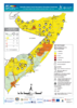
Every single district in Sool had the 1/4 of the households being fed 25-50% of their daily caloric needs there's 6 bags in Sool vs only 2 in what you consider "SL". I'll concede that Togdheer is worse off since that's what the map is saying but Awdal and the Waqooyi Galbeed are doing better.
If you don't understand what that means -> the NGOs are providing in some up to cases 50% of the caloric intake for you
Wtf would the bags mean otherwise lmao the bolded text isn't contradicting me whatsoever
No I didn't I just grabbed it off an old thread
Meanwhile in Awdal, Togdheer and the Waqooyi Galbeed, the people are aided to a much lesser extent and on average are doing better.
Berbera is literally a desert that's common knowledge...
The problem here is that you can't comprehend that Sool is an inhospitable wasteland that's sparsely populated and gets little rain.
Btw the map is from Oxford University
Mean annual precipitation (mm) from the Worldclim data base (Hijmans et al.,
2005). Thin white lines: 1500 meters amsl contour line. Straight lines locate the transects shown in Figure
9.
"Climate of Eastern Africa" published on by Oxford University Press.

oxfordre.com
Here's another map
View attachment 129840
Don't whine and say it's not 2020 bcs it's not radically different whatsoever - still a very dusty place
I can't waste your time with a guy who believes his clan is 1 million strong, you're allergic to reason