2014 UNFPA population estimation, district information released

Status
Not open for further replies.

Thegoodshepherd

Galkacyo iyo Calula dhexdood
VIP
VP3klaq.png

XSFqr55.png

dbNxssu.png

FSw4J9s.png


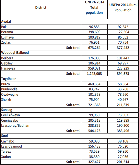
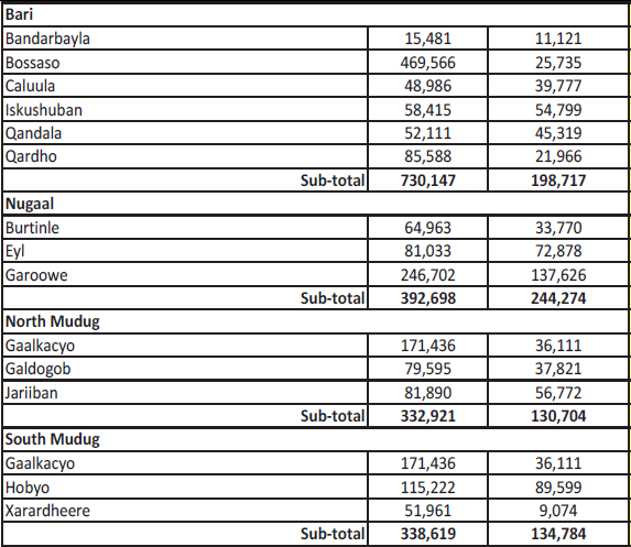
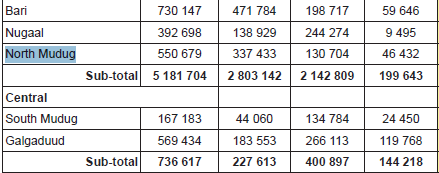
This is the first time a UN agency has published the district breakdown of the 2014 population estimation. It seems that it was somewhat political in that it divided Mudug in two and gave North and South Mudug an equal population, but if you look closer you will see that North Mudug is far larger than South Mudug. They reveal this when they have to give the population breakdown in termsof urban, rural and IDP. North Mudug having 337K urban population to South Mudug's 44K. North Mudug has a larger population than well populated regions like Hiiraan or Middle Shabelle.
dbtIpAY.png


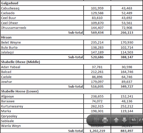
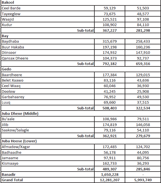
Interesting fact is that Afmadow/Xagar district has more people than Kismayo district. And that the largest district in Sanaag is Las Qorey/Badhan. Bandar Beyla is the smallest district at 15K, and Hargeysa is the largest district at 960K. Some gobols are not growing at all, and are losing population to Banadir, which is now past the 2 million mark.

This is the first district breakdown since 2005, 11 years ago.

Source: http://www.fsnau.org/ipc/population-table
 
Last edited:

ReeBorama

"I'd kill for a Noble Peace Prize"
Interesting. So is this any different than the recently published pop estimate by the UN and SFG which Aynte was spearheading, and how reliable is it?

TGS, so what's your take on the North, I am not surprised at all that my city is up there with the biggest districts in Somalia in general. After Mogadishu n Hargeisa, it's Bosaso, Burco, Borama and Galgacayo which is now divided into two to its disadvantage.


I am also quite apprehensive about the large population growth in certain areas in the last decade, some almost doubling in numbers, what do you say to that?
 

Bohol

VIP
Sool is the least populated region. I can believe that because I have been there the entire eastern Sool is almost empty on the main road.
 

ReeBorama

"I'd kill for a Noble Peace Prize"
Who lives in Lower Shabele, damn niggaz are eating with 7 districts, that's more than any region looool, and where is Qoryoolay ( pics), it's as big as Burco and Borama ?

:ayaanswag::faysalwtf::yacadiim:
 

Thegoodshepherd

Galkacyo iyo Calula dhexdood
VIP
@Duke of Harshaw

Ceerigabo is a 50-50 district. You have places as far east as Ceel Buux and as far west as Masagan, separated by 100 km, being inside Ceerigabo district. Don't assume anything :ftw9nwa:

@ReeBorama
The north, and by that I mean former British Somaliland, is only about 28% of Somalia's population. It is not even 1/3 as I would have assumed.
This means that 72% of Somalia's population is in koonfur.
Qoryoole is the largest agricultural producer in Somalia which is why its population is close to 300K.
 

Bohol

VIP
@Thegoodshepherd Land mass does not equal population.
Majority of Ceerigaabo district population is Gadhweyn, they are at least 75% of
the distrct + other H-Y sub clans. If we measured population by land mass then
Caynabo district would have had a bigger population than Buhoodle district.
 
Last edited:

ReeBorama

"I'd kill for a Noble Peace Prize"
@Thegoodshepherd, you couldn't resist it could you, nacas :lol:

I was hoping for a bit of an objective informational exchange and you just went straight to fadhikudirir, our zones be bigger than your zone :deadrose:

And if you consider the Northeast and Central regions Koonfur, so be it. :chrisfreshhah:
 
Last edited:

Thegoodshepherd

Galkacyo iyo Calula dhexdood
VIP
@Duke of Harshaw I don't want to argue this in this thread. We will never agree on who is the majority in Ceerigabo district.

@ReeBorama, koonfur is Italian Somaliland, it is not a geographical term, and btw this is the same population estimate published by Caynte, they just did not break it down into districts for political reasons. FAO did just that because they need to know how many people to give aid to in each region. FAO does not care about the political implications so they published it in their report. Notice how UNFPA divides Mudug evenly between north and South, wile FAO just straight up tells you the actual population division. One is taking politics into consideration while the other is just giving facts.
 

Hemaal

Jet life till my next life
VIP
what is the method they used to estimate these figures? I'm not buying any population figures until door to door census is held.

This is what i want to know! Anyways we can know figure of Somaliland's population once the voter registration is complete. This are just estimated figures
 
I don't believe these UN "census". Whatever UN employee is leading the census has control of the numbers (i.e. his clan is landheere in the census).
 
Laasqoray and Badhan = 230+ thousand? Taleex has 73 thousand people? That's bullocks. :lol: How the hell could Taleex be remotely close to Buuhoodle when Buuhoodle is like 100 times the size of Taleex?

@Duke of Harshaw, my cousin Thegoodshepherd is right, more than half of Ceerigaabo district is actually Daarod. The only Habar Yonis subclan in Ceerigaabo district is Muse Ismaail and there is a very small minority of Biciido, an unknown Habar Jeclo sub clan that lives amongst the Muse Ismaail. :lol:
 
Lasqoray/Badhan population 230K+ misrepresented as usual even if it was true I'd rather we keep a steady birth rate

>inb4 Le usual extinct meme
 

Bohol

VIP
@Kalshaale both Muuse Carre and Sacad Yoonis have thousands
of residents in Ceerigaabo district. Maydh (the largest coastal town in central/western
Sanaag) mayor is Muuse Carre. Xarshaw also belongs to Sacad Yoonis. This is the
current district representation in Ceerigaabo district.

Ceerigaabo district MPs

9 - Gadhweyn
1- Sacad Yoonis
1- Muuse Carre
(total H-Y Bari - 11)

Warsangeli - 2
Dhulos - 5
HJ - 2


With the backing of SY and MCarre we made sure Ismaaciil Xaaji Nuur was elected for 10 more years, with a clear over 70% majority.

:denzelnigga:


dwOju.jpg
 
Laasqoray and Badhan = 230+ thousand? Taleex has 73 thousand people? That's bullocks. :lol: How the hell could Taleex be remotely close to Buuhoodle when Buuhoodle is like 100 times the size of Taleex?

@Duke of Harshaw, my cousin Thegoodshepherd is right, more than half of Ceerigaabo district is actually Daarod. The only Habar Yonis subclan in Ceerigaabo district is Muse Ismaail and there is a very small minority of Biciido, an unknown Habar Jeclo sub clan that lives amongst the Muse Ismaail. :lol:

warsangali dooqon jaaib tuug ah dhulbahante ba lagu saliday. ninyahow WAA disease ku jira somalida oo UU bahan in laga safayo. bal wax idoorka looqoray UU uu muuqan mayaan warsangali uun ladaba dhiggy oday iyo saqir WAA nocan oo kale
maar ee sanaag wada sheegtaan iyo Mar ee dhaan warsangali oo qomiyad kaa tarikh wayen ee dhan anaga ka masuul ah. preposterous to even have the audacity to sit in front of us :faysalwtf:
 

Thegoodshepherd

Galkacyo iyo Calula dhexdood
VIP
,@calaf doon Most somali people have no idea how large and densly populated Eastern Sanaag is. Warsangeli are by far still nomads which makes them look smaller than they are. I would estimate Warsangeli at around the same population size as Bakool or Middle Juba.
 
,@calaf doon Most somali people have no idea how large and densly populated Eastern Sanaag is. Warsangeli are by far still nomads which makes them look smaller than they are. I would estimate Warsangeli at around the same population size as Bakool or Middle Juba.

I think by now we have more land and population then dhulbahante. we have tripled our population while these savages dhulbahante were in usels conflicts
 
Status
Not open for further replies.

Trending

Top