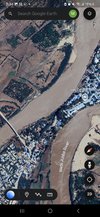
This city is a geographic fortress, just the river enveloping the city proves a strategic barrier to anywould be assault force but the hills on the east and south east side of the city provide cover for a defending force. Especially if you place artillery or any sort long range mortar to fire on exhibit a or b: which I will show you now.

But first an aerial view of Luuq.
The most important and arguably strongest and easiest defensible control/check point.

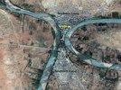
Luuq bridge connects the peninsula to the two main roads entering from the west side of the city. Surrounded by farmland and fields it offers a clear view of any force attempting to attack the city from its main entry point . The bridge is just wide enought for cars to enter one by one and be searched before they enter the city, and in the case of an invading force they would have to cross one by one either on foot or one truck allowing them to be easily picked off one by one by safely and securely positioned snipers and marksmen.
Our second exhibit is the numerous towns and villages surrounding the city acting as mini checkpoints and bases for the Luuq security forces. In total 4 of the larger villages and towns on the western side are located on or alone the main roads from the south, southwest and northwest that can prove vital and be used as the first line of defense against a first wave which luckily would be stopped them and there and having to fall back to the bridge would be a last resort.
Additionally assuming the second point of contact (the bridge is breached) both southern Luuq and Northern Luuq specially the latter are situated on bottleneck which 100 meters at its thinnest area.

There is also one more entrance the less maintained road into south Luuq. As equally defensible as it's counterparts it's only a half mile between the road and the highest elevation point of the hilly terrain next to it.

Another look at Luuq bridge.

But first an aerial view of Luuq.
The most important and arguably strongest and easiest defensible control/check point.
Luuq bridge connects the peninsula to the two main roads entering from the west side of the city. Surrounded by farmland and fields it offers a clear view of any force attempting to attack the city from its main entry point
. The bridge is just wide enought for cars to enter one by one and be searched before they enter the city, and in the case of an invading force they would have to cross one by one either on foot or one truck allowing them to be easily picked off one by one by safely and securely positioned snipers and marksmen. Our second exhibit is the numerous towns and villages surrounding the city acting as mini checkpoints and bases for the Luuq security forces. In total 4 of the larger villages and towns on the western side are located on or alone the main roads from the south, southwest and northwest that can prove vital and be used as the first line of defense against a first wave which luckily would be stopped them and there and having to fall back to the bridge would be a last resort.
Additionally assuming the second point of contact (the bridge is breached) both southern Luuq and Northern Luuq specially the latter are situated on bottleneck which 100 meters at its thinnest area.
There is also one more entrance the less maintained road into south Luuq. As equally defensible as it's counterparts it's only a half mile between the road and the highest elevation point of the hilly terrain next to it.
Another look at Luuq bridge.