Some neat 17th/18th European cartography of the Somali Peninsula

Status
Not open for further replies.
38159.jpg
Abraham Ortelius (also Ortels, Orthellius, Wortels; 14 April 1527 – 28 June 1598) was a Flemish/Netherlandish cartographer and geographer, conventionally recognized as the creator of the first modern atlas, the Theatrum Orbis Terrarum (Theatre of the World). One of the founders and the notable representatives of the Netherlandish school of cartography in its golden age (the 16th and 17th centuries), he is also believed to be the first person to imagine that the continents were joined together before drifting to their present positions.
Antwerp / 1598 - issue
800px-Abraham_Ortelius_by_Peter_Paul_Rubens.jpg
Nice old color example of Ortelius' famous map of the Kingdom of Prester John, from Ortelius' Theatrum Orbis Terrarum, the first modern atlas of the world.


45887.jpg
Theodore De Bry Frankfurt / 1599
"
Rare De Bry edition of eastern portion of Cornelisz Claesz's map of the area extending from Africa to Southeast Asia and Northern Austalia, centered on India and the Indian Ocean.

De Bry's map is an early re-issue of a rare map of Africa and the Atlantic and Indian Oceans, designed to illustrate the first Dutch expedition to Java undertaken by Cornelis de Houtman, 1595-1597. Houtman's route of the voyage is indicated.

The pioneer voyage by the Dutch to Southeast Asia took place in the years 1595-97, under the leadership of Cornelis De Houtman. He established several commercial relations, e.g. with the great pepper port of Banten on the north west coast of Java, near which the Dutch colony of Batavia would soon be founded.

This expedition gave Holland first-hand data about the Sunda Strait, the northern coast of Java, and the island of Bali. News of this voyage was related in several works. Most important was the Historie van Indien, published by Cornelis Claesz in 1598. The book was supposed to contain a new general map of Southeast Asia, but the map was suppressed.

The suppressed map was published by Claesz later the same year as a loose-sheet, and a year later, de Bry published the account of the voyage together with a general over view map and other maps. This map shows the route of the Dutch across the Indian Ocean to Java and back."

Theodor_de_Bry_self_portrait_1597.jpg


zang1.jpg
- 1687
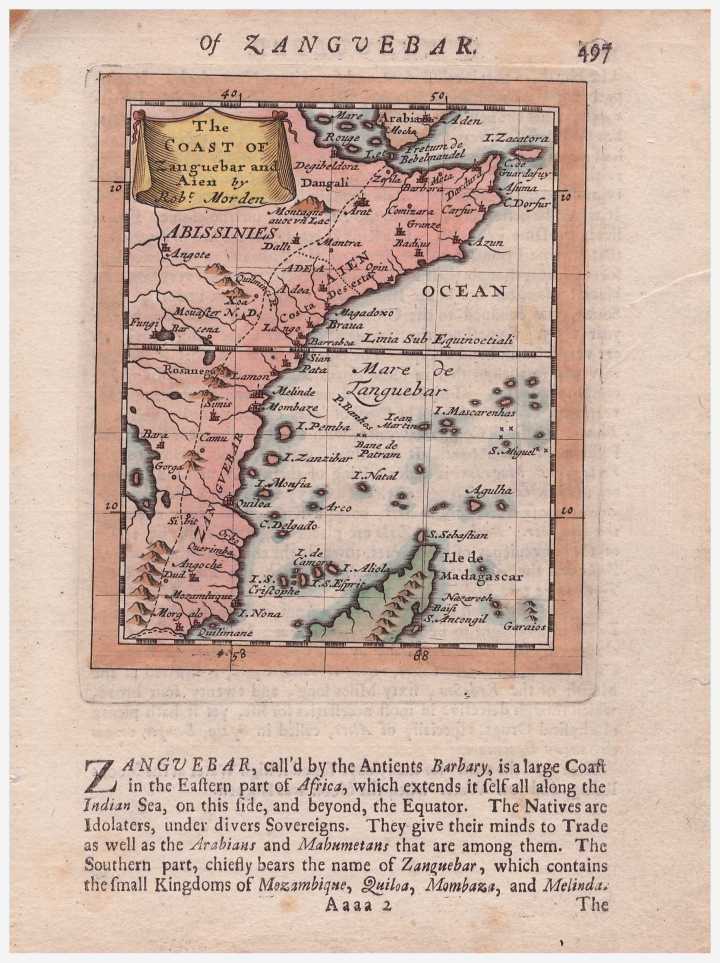
Robert Morden (c. 1650 – 1703) was an English bookseller, publisher, and maker of maps and globes - coloured version.
This map appeared in Modern's rare Atlas Terestris, first published in 1687

5472.jpg


m2737.jpg
1683 By Alain Manesson Mallet (1630–1706)
Allain_Manesson_Mallet_1683.png

(1630–1706) was a French cartographer and engineer.


m2091.jpg
1707 Leiden
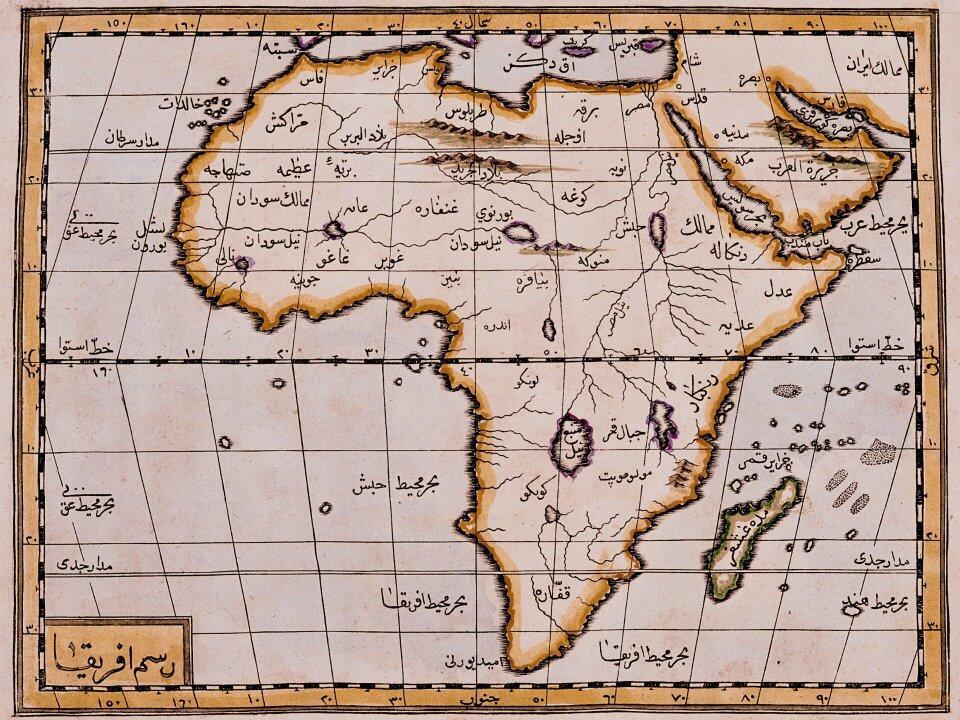
Pieter van der Aa (Leiden, 1659 - Leiden, August 1733) was a Dutch publisher best known for preparing maps and atlases, though he also printed pirated editions of foreign bestsellers and illustrated volumes. He also printed many maps that were often out of print, which he reissued. Some of his most popular maps were of the African continent, detailing locations such as Morocco and Madagascar. Many of his later works were printed for the general public in French and Dutch.


46814.jpg

Johannes Van Keulen - 1699 ca
ohannes van Keulen (1654, Deventer - 1715, Amsterdam) was a 17th-century Dutch cartographer. He published the influential nautical atlas the Zee-Atlas and the pilot guide Zee-Fakkel (meaning Sea-Torch in English).
 
m533.jpg
1610 Amsterdam
Gerardus Mercator (5 March 1512 – 2 December 1594) was a 16th-century German Netherlandish cartographer, geographer and cosmographer.
250px-Mercator.jpg


m1964.jpg
- 1670 London
John Ogilby (also Ogelby, Oglivie; November 1600 – 4 September 1676) was a Scottish translator, impresario and cartographer.
OgilbyPortrait2.jpg


50142.jpg
Paris 1657
Nicolas Sanson (20 December 1600 – 7 July 1667) was a French cartographer, termed by some the creator of French geography, in which he's been called the "father of French cartography.

49088.jpg
- 1655

Sanson was the Royal Geographer to the King of France and perhaps the most important commercial mapmaker of his generation.
220px-Nicolas_Sanson_AGE_V09_1802.jpg


m2617.jpg
1640 circa Amsterdam
Joan Blaeu (23 September 1596 – 21 December 1673) was a Dutch cartographer born in Alkmaar, the son of cartographer Willem Blaeu.
800px-Joan_Blaeu_%28J.van_Rossum%29.jpg


m3435.jpg
1667 Picart Jollian
 
m2809.jpg
1740 Paris
Jacques-Nicolas Bellin


45910.jpg

Henrick Doncker (Dutch cartographer)
Amster 1669 C
Rare Sea Chart of Australia, Southeast Asia and the Indian Ocean

Rare early pair of sea charts of Australia, the Indian Ocean and contiguous regions from China to Africa and the Middle East, first published by the Hendrick Doncker in Amsterdam in his De Zee-Atlas of Water-Werelt . . . in 1669.

The charts illustrate the Dutch sphere of influence in Southeast Asia and Australia. The charts include details of the Dutch discoveries in Australia of Hartog (1616); Houtman (1619); the Leeuwin (1622) and Carstenszoon (1623); as well as de Wits (1628); and Tasmans second voyage in 1644 (Northern Australia) and Peter Nuyts exploits (1627).

The charts are relatively close copies of an equally rare pair of charts by Johannes van Loon, first published in 1661 and by Jacob and Casper Theunis Jacobsz in about 1666, who took the name Lootsman (sea pilot) to avoid confusion with another Amsterdam publisher of the name Jacobsz.

Both the Van Loon and Jacobsz charts are in turn based on an earlier set of sea charts first published by Hendrick Doncker in 1660, although the charts are now oriented such that the map extends a bit further to the South and West.


tumblr_mk7fxh9KQa1rasnq9o1_1280.jpg
- Ottoman Empire cartography, circa 1600
 

DuctTape

I have an IQ of 300
Very interesting.
Threads like these need much more activity than the qashin that gets 200+ replies nowadays sxb.
Interesting how some of the maps say "Ajan Coast" for Somalia. Wonder what that means.
 
Very interesting.
Threads like these need much more activity than the qashin that gets 200+ replies nowadays sxb.
Interesting how some of the maps say "Ajan Coast" for Somalia. Wonder what that means.

Ajuuran coastline as @Shangani has pointed out.

Ajuuran sultanate was a brilliant Somali civilisation, I wish we knew more of their rulers and their mysterious coinage. Some manuscripts from that era would be neat too.
 
https://en.wikipedia.org/wiki/Azania

"Pliny the Elder
mentions an "Azanian Sea" (N.H. 6.34) that began around the emporium of Adulis and stretched around the south coast of Africa."

Adulis was the port of Axum. Depending on the author and the period, Azania either began there or as far south as Kenya. In the 17th-18th centuries the Ajuraan were either gone or on their way out, so I doubt "Ajan" refers to them. "Azan" sounds a lot closer and the "ia" is just a function of language. The Azania ruled by Himyar included the Banadir, Socotra and Cape Aromata, and this looks like a continuation of that usage.


As far as can be determined, the Ajuraan were unknown outside of Somalia.

https://operationoverload.wordpress.com/2009/04/29/the-ajuuraan-dynasty-of-the-hawiyya/
 
Status
Not open for further replies.

Trending

Top