Norweigan oil company Spectrum Geo writes new report about Somalia's offshore oil prospects

Status
Not open for further replies.

Crow

Make Hobyo Great Again
VIP
The Scent of Oil amongst Gas

In the last decade several large Gas discoveries have been in East Africa, with up to 200 tcf of gas, equivalent to more than 30 Bbbl of oil reserves, have been discovered in Mozambique and Tanzania in recent years.

These huge discoveries are currently being queued up for development and are seeking an export market.

It is then with great excitement that Spectrum’s new seismic data, collected between 2014-2016 offshore Somalia, has revealed what has been previously missing from the East African margin – the scent of oil.

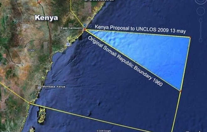
As Somalia announces plans to open its first offshore exploration license round, (orange, left) explorers analysing new seismic data have recognized the potential of finding reserves to match those of its neighbours in East Africa.

Beyond that, critically, they are discovering that Somalia’s potential is not just gas: Here lies a gem of an unexplored oil basin.
Round Timeline Set in place

A date of 7 February 2019 has been set for an auspicious launch event in London at Claridges Hotel when the Ministry of Petroleum and Mineral Resources will unveil the final block delineation,
expected to consist of up to 50 blocks covering a total area of over 173,000 km^2. During this launch they also plan to reveal the legal & regulatory framework, petroleum laws, local capacity, fiscal terms, round timings and other conditions. This event is also expected to include geological presentations gained through insight provided by Spectrum’s 2D seismic data across the open blocks. The round is set to close on 11 July 2019.
The Oil Source Question

This 2D seismic data is being interrogated by geoscientists to demonstrate the presence of the three critical factors for oil to be trapped underground. There must be a source rock – shale containing organic material that is buried at the right temperature and pressure conditions for generation. The oil that is formed must then flow through pores and fractures to a reservoir where it collects, displacing water between grains of sand, and then this oil must be trapped – where it is held underground by impermeable strata. Analysis of the new seismic data offshore Somalia has allowed the critical factors of this puzzle to be identified.

In Somalia, indeed, in any unexplored basin, an explorer’s first question is whether there is a source rock that has been buried deep enough to be mature. If the source rock is too cold (i.e. buried insufficiently) then no oil forms. If the source rock is too hot (i.e. buried too deep) then the oil is cracked or broken down to methane gas. Yet like good-tasting porridge, if the temperature is just right, the source rock will produce oil product in what is called the Goldilocks Zone.
Basin Structure

Broadly, the geology of the Somalian margin can be divided into a northern zone (the Obbia and Coriole basins) underlain by highly stretched continental crust (sands, shales, limestones, and old metamorphic rocks), and a southern zone (Juba-Lamu basin) underlain by oceanic crust (volcanics). In the northern area, the temperature in the earth increases rapidly with depth such that the main source rocks (Jurassic) lying a modest 2-3 km (1.2-1.8 mi) below the seabed, are mature for generating oil rather than gas today. In the south, the underlying colder oceanic crust lets the temperature rise only slowly with depth such that the main source rocks that are more deeply buried (3-4 km/1.8-2.4 mi) in this region are serendipitously still generating oil today. Oil as the primary hydrocarbon phase offshore Somalia is supported by observation on satellite data of clusters of repeating natural oil slicks on the ocean surface.
Conclusions

The announcement of the country’s upcoming license round is perfectly timed to coincide with the availability of new seismic data. This excites international geoscientists by demonstrating a clear oil-prone series of prospects offshore the whole length of the Somalian margin. In the north, large tilted fault blocks, reefal buildups, and huge anticlinal folds of rock are seen to lie next to oil generative source kitchens. In the south, huge structures similar to those seen in the super giant Rovuma basin (Mozambique) discoveries have been observed sitting over oil-prone rather than gas-prone kitchens. Additionally, large, well-defined fold belts are found in the near-shore section offering targets that are cheap to drill with very attractive potential.

The first drilling in this exciting basin is expected to occur as early as 2018, and should open the door to this new oil province bringing much needed benefit to Somalia and a new economic stability to the region. Somalia exploration has been dormant for a generation. In those 25 years of sleep, the international exploration industry has transformed the technology available for seismic acquisition, processing, interpretation, and drilling.

Now Somalian exploration awakens to a new world with incredible new technologies and the capability to reduce exploration risk and ensure early success. It awakens not only to a stable government with capability and intent to rapidly develop Somalian natural resources, but also to the recognition that this is the part of East Africa where hydrocarbon wealth will not just be defined by the development of long-term gas projects, but from the discovery of earth’s richest natural resource prize – oil.
  • Created by
    Phil Hargreaves and Robert Macdonald
  • Supported by
    The Somalian Ministry of Petroleum and Mineral Resources
Click the links to see the full report and a detailed map.
http://spectrumgeo.maps.arcgis.com/apps/Cascade/index.html?appid=c25e07e456f0414abcb54abfc1f896b0
http://www.arcgis.com/apps/webappvi...,-408877.5424,6214667.8259,827567.8271,102100
 

Crow

Make Hobyo Great Again
VIP
Here is the map.
Somalia oil map.jpg


As you can see, the oil blocks up for bid include those off of the coast of Garacad, the same place that Farmajo and Kheyre spat on this past August when they refused to endorse our wholly Puntland funded port project.
Northern Somalia oil map.jpg

We will be waiting there next year with our technicals and gunboats if we are not paid our dues.


Also worthy of note, blocks 230-234 are being put up for bid even though Kenya claims them and there is a case still going through international courts regarding the boundary.
Southern Somalia oil map.jpg

As you can see, the grid line follows the correct boundary and the FGS has still not given up on it (even though they are the ones that got us in this mess in the first place).
 

Crow

Make Hobyo Great Again
VIP
So the good news is that offshore oil is now confirmed and we are maintaining our claim on our southern waters.

The bad news is we have a booon with down syndrome and his pet langaab huutu danyeer in Villa Somalia who won't miss the opportunity to wreck everything.
 
It seems to stretch down to Kenya. Somalis should hurry up and reclaim NFD before these Bantu landgrabbers drain all of the oil that is rightfully ours.
 

Farm

VIP
Why is north Mudug up for grabs? The FGS has another thing coming if they think they can take my oil.

Imagine trying to exploit oil when you barely control a block in your capital.

:heh:
 

Crow

Make Hobyo Great Again
VIP
It seems to stretch down to Kenya. Somalis should hurry up and reclaim NFD before these Bantu landgrabbers drain all of the oil that is rightfully ours.
We already have NFD waters. That's what Kenya is trying to steal.
201683636058323274218607medium_h6AFPVkvX660.jpg

250px-North_Eastern_in_Kenya.svg.png
 

Farm

VIP


Remember this.


Look at the offshore figures.


The next president of Puntland better renegotiate this terrible agreement.
 
Oil profits will just go to Shabaab anyway.

We need to secure all of Koonfur before we even think about oil. We need to negotiate funds for a navy to protect our shores while we're at it. And we also need to stop Kenya's claim of our waters.

It's not all bad though, the oil is far from Socotra, so those Yemen rats can't claim it. It's all up to Villa Somalia not to f*ck it up, as @Crow says.
 

Farm

VIP
Oil profits will just go to Shabaab anyway.

We need to secure all of Koonfur before we even think about oil. We need to negotiate funds for a navy to protect our shores while we're at it. And we also need to stop Kenya's claim of our waters.

It's not all bad though, the oil is far from Socotra, so those Yemen rats can't claim it. It's all up to Villa Somalia not to f*ck it up, as @Crow says.


There is oil offshore northern PL, the same company unfortunately plans to explore the coast sometime in late 2019 and drill in 2020. While drilling is set to begin in south central regions (including North Mudug which won’t be happening under my watch ) by 2019.
 
So the good news is that offshore oil is now confirmed and we are maintaining our claim on our southern waters.

The bad news is we have a booon with down syndrome and his pet langaab huutu danyeer in Villa Somalia who won't miss the opportunity to wreck everything.
We need new politicians. Also notice how most onshore oil is in the north and most offshore oil is in the south. It's like fate sparring our home bred retards from fighting over the oil since it will be split 50/50 thanks to nature and geology anyway.

I hope corruption is crushed and the money is spent on education and infrastructure and tourism.
 
Oil profits will just go to Shabaab anyway.

We need to secure all of Koonfur before we even think about oil. We need to negotiate funds for a navy to protect our shores while we're at it. And we also need to stop Kenya's claim of our waters.

It's not all bad though, the oil is far from Socotra, so those Yemen rats can't claim it. It's all up to Villa Somalia not to f*ck it up, as @Crow says.
Yemeni rats are busy with saudi dogs. I say we take socotra now while they are busy at war.

:trumpsmirk:
 

Crow

Make Hobyo Great Again
VIP
Oil for Development in Somalia
05. Nov 2018
ofu1.jpg

Last week, 30 Somali delegates and 10 Norwegian experts were gathered in Nairobi to discuss and identify the content of a future Oil for Development program in Somalia. The Somali delegation comprised the Minister of Petroleum and Mineral Resources, as well as delegates from the Ministry of Finance, the Ministry of Fisheries as well as representatives from several of the Somali member states. From the Norwegian side experts from the Ministry of Petroleum and Energy were present, together with other experts on environmental and financial/macro-economic issues.
ofu2.jpg

The workshop led to increased understanding of the potential contributions from Norway to Somalia in an Oil for Development program, and laid the foundation for further details and content in a program. Both sides were very pleased with the progress made during the workshop, and further meetings between individual institutions are planned for the next months.
https://www.norway.no/en/kenya/norway-kenya/news-events/news2/oil-for-development-in-somalia/
:fantasia2:
 

Oortcloud

Expert in jinn exorcism-jinni ceejiye
Here is the map.
View attachment 59066


As you can see, the oil blocks up for bid include those off of the coast of Garacad, the same place that Farmajo and Kheyre spat on this past August when they refused to endorse our wholly Puntland funded port project.
View attachment 59067
We will be waiting there next year with our technicals and gunboats if we are not paid our dues.


Also worthy of note, blocks 230-234 are being put up for bid even though Kenya claims them and there is a case still going through international courts regarding the boundary.
View attachment 59068
As you can see, the grid line follows the correct boundary and the FGS has still not given up on it (even though they are the ones that got us in this mess in the first place).
Sorry but the exploration doesn't include pl otherwise they would have enlarged the line to include all way bosaso caluula the reason it doesn't stretch is pl rejected the exploration and was left out the map is hawiye centered one
 

Farm

VIP
Sorry but the exploration doesn't include pl otherwise they would have enlarged the line to include all way bosaso caluula the reason it doesn't stretch is pl rejected the exploration and was left out the map is hawiye centered one


Are you blind? It clearly goes past north Mudug, and if you read the article they said northern Puntland will be the next phase later in 2019, the first phase is North Mudug (Puntland) and below.


You don't have permission to view the spoiler content. Log in or register now.
 
Last edited:
Status
Not open for further replies.

Trending

Latest posts

Top